The historical note was contributed by Bill Pohnan.
', latitude=>'42.1175', longitude=>'-88.3024', minlat=>'42.07', minlon=>'-88.25', maxlat=>'42.17', maxlon=>'-88.35', trackMapOHM=>'3', trackMapEmbedZoom=>'15', trackMapOHMAdditionalLayers=>'[ { name: "1962 Aerial Image", tiles: "https://mapwarper.net/maps/tile/45231/{z}/{x}/{y}.png", attribution: "USGS Earth Explorer" }, { name: "1967 Aerial Image", tiles: "https://mapwarper.net/maps/tile/45232/{z}/{x}/{y}.png", attribution: "USGS Earth Explorer" } ]', mapService=>'Yahoo', foodService=>'Yahoo', hotelService=>'Yahoo', offsiteTOCInsertLink1 => '', offsiteTOCInsertText1 => '', historicalNote => 'Meadowdale International Raceway was a 3.27 mile track located in Carpentersville, Illinois. This challenging course combined features of both oval track and open road racing. A 4000 foot long main straight and huge Monza Wall were just two of its more notable features. Most of the track was laid out on flat, open farmland, but the eastern portion featured curves, climbs and esses that undulated through a forest and over the western side of the Fox River Valley. The facility opened during the weekend of September 13-14, 1958 - a mere six months after the building permit was issued. A reported 150,000 spectators saw Chuck Daigh win the Feature Race in a Scarab. Racing continued at Meadowdale into the mid-60\'s, but attendance steadily declined due to several factors including: massive traffic jambs caused by the limited local infrastructure, changing race schedules resulting from conflicts with various sanctioning organizations and poor spectator conditions (long walks from the parking area, heat, dust etc). The course underwent a major renovation about 1967, during which the famous Monza Wall was leveled, and other improvements made Efforts to boost attendance by altering the original course, promoting motorcycle and snow-mobile racing, and changing management all proved fruitless. Racing all but ceased after the 1968 season. By the early \'70s the track had deteriorated to the point where talk of reopening the facility stopped.
', trackMap => '
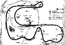
This is the so-called "Fat Map" which substantially
misrepresents the proportions of the track.
